Summer is my season. You might think that I’d be enamored with snow, being a meteorologist and having grown up along Coastal California, where seeing snow involved a 6-hour drive to Tahoe. I do enjoy snow – there’s nothing like a good blizzard on some long weekend in February when I can hunker down at home with a cup of tea and watch it snow enough to where finally put on my skis and head over to the neighborhood park. But 8-inches in late May? (Heads up: basic meteorology lesson coming!)

Heavy snowfall, just getting underway on Thursday, May 18, 2017.
This is Colorado – always teasing you with a new cloud on the horizon. In mid-May temperatures hovered in the mid-80’s. The air on my street hung heavy with barbecue smoke in the evening. Kids played in sprinklers, and everyone was settling into the mode of flip-flops and shorts and ice cream on the porch. May 15th heralds the end of the average last-day-of-frost, and garden centers were buzzing with people stocking up on tomato and zucchini seedlings.


I love watching the parade of perennials blooming in my front yard at this time of year. By mid-May, the purple salvias and red valerian are just popping out. The Oriental Poppies are wrapping up their show.


I hadn’t planted any veggies yet. I saw the big dip in the jet stream coming. I knew it would get a bit cold and wet, and I expected a little snow and a night with temperatures around 30F. Winter’s last hurrah.
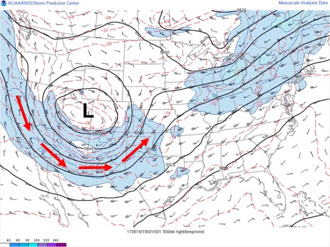
Without getting into too much meteorological geekiness, the lines on this weather map tell us about air flow patterns at high altitude during the peak of the storm. You can imagine the jet stream following a path laid out by these lines* (and by the red arrows). The jet stream helps to move storms from west to east, and when it dips to the south, storms tend to move further south. (*MET people: of course, better to look at the 250 or 300 mb map for the jet stream!)
It was hard to tell what was going to happen, exactly, as the forecasts weren’t entirely consistent regarding how cold it would get. The precise positioning of the low pressure system, direction of low level winds, and amount of moisture can make for big regional differences in snowfall totals.

Poppies in the driving snow…
I think what surprised me most was how early the rain turned to snow as the storm moved through. By 7am on May 18th morning, there were big, sticky flakes falling fast enough to begin to cover the pavement within an hour. By 10am, I was outside trying to shake piles of snow off of some of my trees and bushes. This was snow so wet that it soaked through my winter gloves in a minute. And there was no reprieve – it snowed ALL day.
Fort Collins got hammered more than most places along the Front Range. Greeley got a couple of inches, but not until much later in the day. Denver didn’t receive nearly as much either.
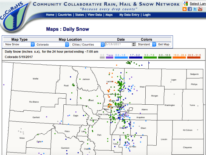
Screen shot of the CoCoRaHs snow depth report from May 19th. The highest snow totals were right up along the Front Range and into the hills (Estes Park had a couple of feet!). But snowfall totals tail off quickly as you move eastward, where most of that moisture fell as rain.
We tend to see snow like this when the surface low pressure systems pass to the south, directing winds that come from the east through northern Colorado. Those low level winds turn southward right up along the Front Range. So, near the ground, winds come from the north, pulling cold air along the slope of the Front Range. (We call this cold air damming – because the mountains basically act as a dam against the cold air).
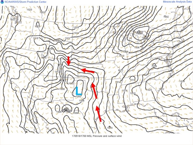
This weather map shows contours of pressure – this tells us about wind direction during the storm. Air moves in a counter-clockwise path around low pressure systems in the northern hemisphere.
Above this, winds come from the south, helping to draw moisture from the Gulf of Mexico. As this moisture passes over cold air along the Front Range, it feeds those heavy snowfalls (or rainfall, 20 miles away, a bit further from the mountains).
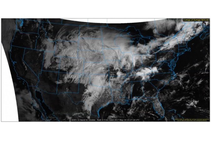
Above: The mass of clouds associated with this storm, moving across the US.

At the peak of the storm, the tall hedges next to my driveway were flattened. Post-snowstorm they are no longer so tall.
I have to admit, it was a bit disheartening watching the snow melt back, seeing the perennials flat, bent and broken. They’re coming back up slowly – most of them anyway. Since the storm, temperatures have already popped back up over 80F, and the piles of white stuff have long been replaced by some very green grass.
Wavy jet streams can do this, and that’s not uncommon at this time of year. Ultimately, what shapes the path of the jet stream is a complex interplay between what’s going on in the tropics and what’s happening in the Arctic. Changes in either place (e.g., El Niño or reduced Arctic sea ice due to global warming) can impact the path of the jet stream, and affect our experience of extreme weather (for science-types who want a more detailed explanation, here’s a reference for you). Ultimately, this is why I had to put ‘2017’ in the title of this post. There’s bound to be another late-spring or early fall snowpocalypse at some point, probably bounded by drought or really hot weather. Welcome to the world of atmospheric variability.

Thanks for the science lesson. Glad you got the snow and not us. Rain and cold were bad enough.
LikeLike